


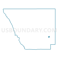
Larimer 329, Larimer County, Colorado
About
Outline

Summary
| Unique Area Identifier | 548743 |
| Name | Larimer 329 |
| County | Larimer County |
| State | Colorado |
| Area (square miles) | 1.21 |
| Land Area (square miles) | 1.21 |
| Water Area (square miles) | 0.00 |
| % of Land Area | 100.00 |
| % of Water Area | 0.00 |
| Latitude of the Internal Point | 40.48848360 |
| Longtitude of the Internal Point | -105.09434520 |
Maps

Graphs
Select a template below for downloading or customizing gragh for Larimer 329, Larimer County, Colorado


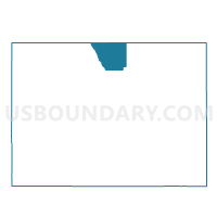
Neighbors
Neighoring Voting District (by Name) Neighboring Voting District on the Map
- Larimer 101, Larimer County, CO
- Larimer 328, Larimer County, CO
- Larimer 330, Larimer County, CO
- Larimer 502, Larimer County, CO
- Larimer 538, Larimer County, CO
Top 10 Neighboring County Subdivision (by Population) Neighboring County Subdivision on the Map
Top 10 Neighboring Place (by Population) Neighboring Place on the Map
Top 10 Neighboring Unified School District (by Population) Neighboring Unified School District on the Map
Top 10 Neighboring State Legislative District Lower Chamber (by Population) Neighboring State Legislative District Lower Chamber on the Map
- State House District 49, CO (83,740)
- State House District 51, CO (80,253)
- State House District 53, CO (69,496)
Top 10 Neighboring State Legislative District Upper Chamber (by Population) Neighboring State Legislative District Upper Chamber on the Map
Top 10 Neighboring 111th Congressional District (by Population) Neighboring 111th Congressional District on the Map
Top 10 Neighboring Census Tract (by Population) Neighboring Census Tract on the Map
- Census Tract 18.09, Larimer County, CO (10,495)
- Census Tract 10.09, Larimer County, CO (6,149)
- Census Tract 11.14, Larimer County, CO (2,311)